

Why a new blog? The Toe River Valley is full of history. From de Soto to the Parkway Play House, the Toe River Valley is packed with events that have both changed people’s lives, and have changed life in America. Over the next few years, I hope to talk about a few of them.
What is the Toe River Valley? The area is composed of Yancey, Mitchell, about half of Avery County, and a little part of Madison County, North Carolina. The crest of the Blue Ridge (along the Blue Ridge Parkway) bounds the area on the south side. To the west is the Walnut Mountain range, and to its south, a series of peaks: Cold Knob, Chestnut Mountain, Sam Doane Mountain, and Sally Mountain. To the east is the Continental Divide - running through Montezuma. To the north, you have Roan Mountain, and the Bald Mountains, and the Unaka Mountains. The Toe River is made up of the North Toe, which begins in Avery County, and the South Toe, which forms in the Black Mountains. They become the Nolichucky River near Peterson.
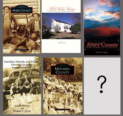
Who am I? I’m Michael. I live in the Toe River Valley area. I also write about the Toe River Valley. To date, I’ve written three books about the area: a pictorial history of Avery County; a collection of essays on Avery County; and a history of the McElroy House in Burnsville. I’ve also written five other books, histories of Watauga County, Caldwell County, and three Civil War books. I am currently working on a book about the 58th North Carolina Troops, a Confederate regiment made up of men mostly from the Toe River area. I also have two other projects in the works that deal with the Toe River Area. I’m a past vice president/president of the Yancey Historical Association and current Vice-Chair of the Avery County Historical Society and Museum. I also work with the Mitchell County Historical Society. I’ve taught classes on local history at Mayland Community College, where I also serve on the library board. And, I’m the worship leader (and on the finance committee) at Aaron Baptist Church, located in Montezuma, just barely in the Toe River area. Finally, I’m a charter member of the Col. John B. Palmer Camp of the Sons of Confederate Veterans, which meets the third Tuesday of each month at the town center in Burnsville.
Did I have ancestors in the Toe River area? Ancestors, no. Cousins, a lot. My North Carolina ancestors first settled in the Yadkin River Valley in the 1750s. They lived in what would become Watauga County for a couple of generations before migrating to east Kentucky. They include the Proffitts, Hamptons, and Laws. Recognize those names? You’ll find them in the Toe River Valley.
I’ll try and post a several times a week. Sometimes, they will be deep, thought-provoking posts. Others will be announcements; a few will be photographs of the area.
Got something interesting on your mind? Drop me a line and tell me about it. Maybe we can work out a guest post for you.

5 comments:
Michael, You are a treasure to people that know you and your family and a true treasure in helping us local mountain folks know and remember our heritage and our history. Thank You. I am researching a very intersting story Lost Cove, Yancey County. It was a community founded by some of my kin folk. This was a thriving community 1864-1957. It was so remote, that there wasn't even a road to Lost Cove. And it survived almost a 100 years. Fasinating story and amazing the strength of these poor mountain families that lived so well with there faith and education as remote as they were. Maybe I could get you and my little buddy to hike with me to Lost Cove. Cindy Ray Peters
How did the Toe River get its name?
The Indians nameed it Estatoe, was later shortened to "Toe" by the White settlers
what does estatoe mean?
I finally made it to Lost Cove on Thursday (9/29/11). A second attempt to locate the community. I had known about Lost Cove because of it's connection with the Clinchfield Railroad. The story by Christy Smith brought the community to life. I wish someone could map out the community and where the houses were located because most are gone now. A very good hike from Poplar, NC via the railroad. If you use this route, please mindful of the trains that can be dangerous. Also, bear in the area, I did not see any live bears this day but there was a recent death of a cub that was on the tracks on my way to the site.
Paul Hess
Post a Comment